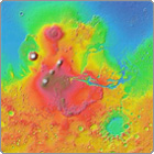
Google has extended its mapping operations outside Earth's orbit with the launch of
Google Mars.
Users can scroll over the surface of the Red Planet and it look at it with a colour coded relief map, an infrared display or an estimation of how the surface would look to the naked eye.
"We here on Earth have long held a fascination with the planet Mars," writes the Google blog.
"From Percival Lowell's sketches of its surface, to the countless books and movies that revolve around it, we've spent millennia studying and day-dreaming about our nearest neighbour in the solar system.
"In that tradition, Nasa researchers Noel Gorelick and Michael Weiss-Malik from Arizona State University worked with us to combine Google Maps technology with some of the most detailed scientific maps of Mars ever made."
In addition to general maps the user can search for particular craters and mountains, and for the landing sites of probes, including Beagle 2.

News Source:
vnunet.com